
The Ice Age Trail in Door County
Published
The nearly 1,200-mile Ice Age National Scenic Trail (IAT) is the crown jewel of Wisconsin hiking.
Weaving its way from Door County all the way to northeastern Minnesota, the trail presents both a tremendous challenge and a tremendous opportunity for long-distance thru-hikers looking to immerse themselves in the geography and wilderness of Wisconsin as well as trail communities that offer quintessential small-town Wisconsin experiences.
Hiking the IAT—whether for a few hours, a single night, several days, or several months—is an absolutely iconic, bucket-list-level Wisconsin experience, and one that you can have while visiting Door County.
The good news is: you don’t have to hike all 1,200+ miles to experience the IAT and get a taste of trail life.
If you’re interested in experiencing this outdoor icon, read on to get some common questions answered and start dreaming up your IAT adventure today.
Fast Facts: The Ice Age Trail
- Location: Wisconsin, USA
- Length: about 1,200 miles
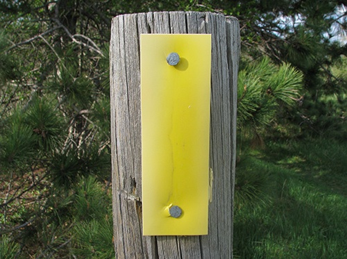
- Blaze Color: bright yellow
- Eastern Terminus: Potawatomi State Park, Sturgeon Bay, Wisconsin
- Western Terminus: Interstate State Park, St. Croix Falls, Minnesota
- Counties Traversed: 30
- Number of Trail Communities: 14, including Sturgeon Bay
- Progress Report: under construction but fully hikeable
- Number of Confirmed Thru-Hikes: 80 (at time of writing)
- First Confirmed Thru-Hike: 1979
- Activities: thru-hiking, backpacking, day hiking, biking, snowshoeing, cross country skiing (some segments), horseback riding (some segments)
Q: What is thru-hiking? What’s it like?
A: Thru-hiking refers to the intentional act of hiking and camping the entirety of a long-distance trail without leaving it for more than a night or two.
The goals are to deeply immerse oneself in nature and wilderness, test outdoor and camping skills, challenge one’s physical and mental fortitude, engage in deep self-reflection, and escape technology and the modern world for an extended period of time, among countless other personal goals and motivations.
Whereas a backpacking trip might last between one night to a few weeks, thru-hikers are usually on the trail for at least a few weeks and might be out there for up to six months or more, depending on pace and many other factors.
The IAT takes most hikers between 2-4 months to complete.
Every hiker is different, but in general they spend their days hiking an established but rugged trail in a remote wilderness area, following colorful trail markers known as “blazes,” and their nights in front of the campsite or in the tent, falling asleep to the sounds of nature after dark.
Q: What makes the IAT special?
A: According to the official Ice Age Trail Alliance:
“More than 12,000 years ago, an immense flow of glacial ice sculpted a landscape of remarkable beauty across Wisconsin. As the glacier retreated, it left behind a variety of unique landscape features. These glacial remnants are now considered among the world’s finest examples of how continental glaciation sculpts our planet.”
The Ice Age Trail is designed to highlight these incredible natural features and provide hikers with an expansive look at the geography and topography of southern and central Wisconsin as it was shaped by glaciation.
The trail’s National Scenic Trail designation in itself is also significant—there are only 11 official NSTs in the country, and Wisconsin is lucky enough to have one to itself (except for that western endpoint on the Wisconsin-Minnesota border).
Q: What’s the trail like and where does it lead? How’s the view?
A: The IAT takes hikers from Sturgeon Bay, Wisconsin all the way to St. Croix Falls, Minnesota. During that journey, hikers will trek nearly 1,200 miles across the state of Wisconsin, pass through 30 counties (including Door) and traverse a huge variety of ecosystems, terrains, and environments.
The views and natural attractions of the trail vary wildly from segment-to-segment (and, really, step-to-step), but in general hikers can expect a relatively low-elevation trek featuring “mature forests, expansive prairies, and thousands of lakes and rivers” as well as “kames, lakes, drumlins, ice-walled-lake plains, outwash plains, eskers, tunnel channels, unglaciated features of the Driftless Area and other older landforms.”
In other words, those who hike the full trail will get a crash course in key Wisconsin geographical features, plantlife, wildlife, waterways, and rock formations.
Q: I’m a visual learner. How about a map?
A: You got it—check out the IAT’s interactive trail map or a static map (PDF) to get a sense of the size, scope, and geographical variety of the trail.
Q: How does this relate to Door County?
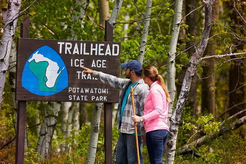
A: The trail’s eastern terminus or trailhead is located on the north end of Potawatomi State Park in Sturgeon Bay, and the city itself is an official Ice Age Trail Community. This means it's highly welcoming to hikers looking to replenish supplies and offers them a taste of “the Wisconsin experience."
The first (or last) few dozen miles of the trail run through Sturgeon Bay, Forestville, and other villages and towns in Southern Door before continuing south into adjacent Kewaunee County and beyond.
This means for every IAT thru-hiker, Sturgeon Bay and Door County serve as either launching points for adventure or as cozy and welcoming endpoints ideal for that first post-trail meal, beer, or real bed.
Q: How can I experience the IAT without overnight camping?
A: The nice thing about most hiking trails is that you can pretty much start and stop anywhere, so no need to commit to hiking thousands of miles to experience the IAT.
In Door County, the Potawatomi State Park trail marker is a great place to start, but you can hop on at nearly any marked trailhead or junction along the 20+ miles of the trail that run through the county and take it as far as feels right for you—whether a mile, a few miles, an overnight, or longer.
Most thru-hiking trails are also broken up into shorter named “segments” (such as the Sturgeon Bay Segment or the Forestville Segment) that day-hikers or backpackers can complete one-by-one. The goal is to eventually hike every segment of a single trail, thereby completing the entirety of the trail slowly, over time.
Q: Can I thru-hike the IAT in winter?
A: If you dare! It will be freezing cold, snow will be a constant trail companion, and icy patches will try to take you down.
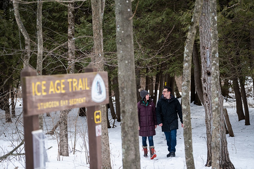
But, if you’re a highly experienced hiker or winter-camper with a lot of grit and a desire for a huge challenge, you’re welcome to take on a thru-hike of the IAT in the wintertime. As of writing, only two people have thru-hiked the entire trail in winter, most recently winter 2020–2021.
Of course, you also hike a segment or two for a chilly but pleasant day trip in the snowy season. The trail is also open to snowshoers in winter, and some segments can be used for cross country skiing.
Q: What are the other major hiking areas in Door County?
A: Some of the top areas in Door County for hiking include the 48-mile Ahnapee Trail, Newport State Park, Peninsula State Park, Rock Island, and the Door County Land Trust properties.
But, with a little more digging, you’ll find there’s no shortage of trails and outdoor spaces in the area—both short- and long-distance—that are perfect for getting outdoors and experiencing the incredible scenery and nature of Door County.
More on the IAT
Looking for even more information on the Ice Age Trail? Explore the official website and check out this video for an in-depth look at the IAT in Door County.
Sign up today!
Visit Door County virtually with monthly newsletter updates. Each issue is jam-packed with vacation ideas, special offers, recipes, festivals, events, and more.